You are viewing an old version of this page. View the current version.
Compare with Current
View Page History
Version 1
Next »
Persistent URL http://auscover.org.au/purl/mangrove-airborne-extent-leichardt-2012 matt.paget we need to update the purl for this link
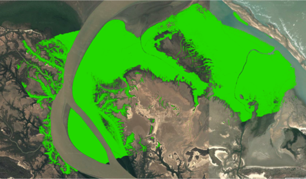
LiDAR data (1 m post spacing; 24 strips approximating 1 km in width) were acquired over the mangroves at the mouth of the Leichhardt River in 2012 by Airborne Research Australia (ARA). To map the extent of mangroves, a 1 m height threshold was applied, with this considered to provide a good representation compared to aerial photography.
Additional metadata - 2012 LIDAR data, Leichhardt River, QLD
Data Licence and Access Rights
| Item | Detail |
Rights | Copyright (if appropriate). Rights owned by Name. Rights licensed subject to Licence Creative Commons Attribution (CC BY 4.0). |
License | Creative Commons Attribution 4.0 License, http://creativecommons.org/licenses/by/4.0 . |
Access | These data can be freely downloaded and used subject to the CC BY licence. Attribution and citation is required as described at http://www.auscover.org.au/citation . We ask that you send us citations and copies of publications arising from work that use these data. |
| Version label | Detail | Format |
2011_Leichhardt_River_MangroveExtent_LIDAR | Mangrove extent mapped from 2012 LIDAR Leichhardt River 2012, QLD | .shp |