...
Welcome to TERN EcoPlots
...
EcoPlots Portal
Coming soon
EcoPlots API
The EcoPlots API provides machine-readable search and download endpoints to support the discovery of ecological plot data. [Read more about Web APIs and Enspoints]
| Note |
|---|
EcoPlots API feeds directly from the most updated available version of the different datasets. Data is updated often, so the amount of sites/observations you receive today might vary from future searches. If you are planning to use this data for research purposes, we recommend using the “data download” feature in the EcoPlots Portal instead and mint a DOI for the package containing the exact version of the data used in your research. |
Accessing the data programmatically is easy using any of the different offered endpoints. However, if your goal is to download large amount of data or have a stable data release we recommend you to download “data packages” directly via the EcoPlots portal, in which you will receive an organised zip package with all data requested based on search criteria.
| Info |
|---|
All API endpoints need system generated API Key to access and retrieve data. [Read more about API Keys] |
...
API authentication using the TERN ApiKey
...
...
...
Request response and output formats
...
The Terrestrial Ecosystem Research Network (TERN) has created a data integration platform to search and access site-based survey data called EcoPlots. TERN EcoPlots maps all site-based survey datasets and opportunistic observations to TERN Ontology, a common information model to represent data.
Data sources in EcoPlots include TERN Surveillance monitoring, TERN Ecosystem Processes, TERN AusPlots Forest and Queensland Biodiversity and Ecology Information System (QBEIS), and it keeps growing.
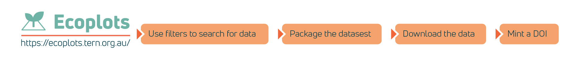
This “getting started” guide will help you to access the EcoPlots data portal and give you an overview of its functionality.
| Child pages (Children Display) | ||||
|---|---|---|---|---|
|
EcoPlots harmonises plot-based ecology data from different sources to enable integrated search and access to data based on different jurisdictions, data sources, feature types, parameters and temporal extent. Data from EcoPlots can be accessed using user interface and via API.
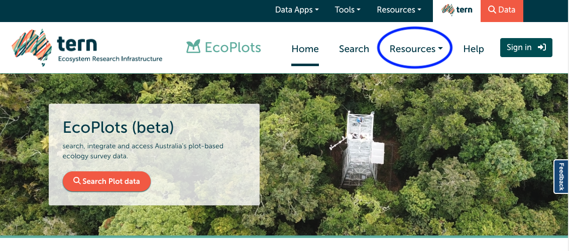
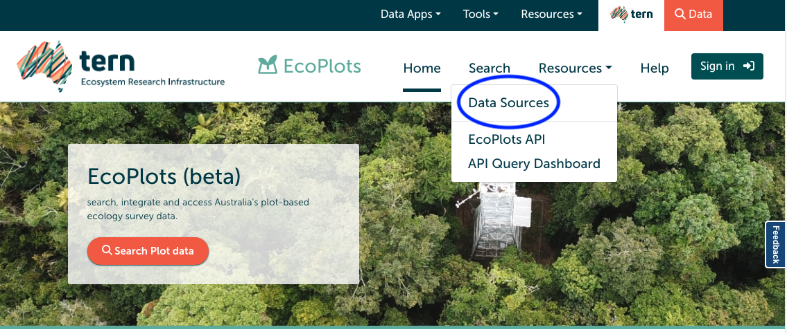
To obtain summary statistics on each dataset housed within EcoPlots, users can click on the “Resources” and “Data Sources” menus on the EcoPlots homepage: https://ecoplots.tern.org.au/.
EcoPlots provides a dashboard view of each individual dataset. Descriptions of each data source are provided below.
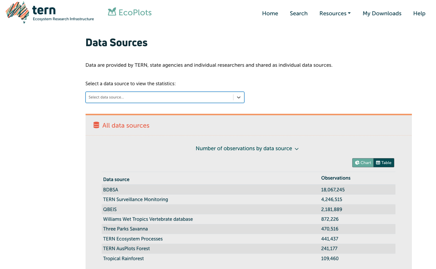
Summary information about each dataset is available in chart or table form by toggling the Chart/Table button in the top right corner of each statistics panel.

Summary of available Datasets
BDBSA – Biological Databases of South Australia is a central access point for South Australian biological data including records from Biological Survey of South Australia, Birdlife Australia, and the South Australian Museum.
QBEIS – Queensland Biodiversity and Ecology Information System contains data from surveys conducted throughout Queensland. Data collection has been taking place in 1982 on various physical and vegetation features, landscape, soil, and geologic features.
TERN AusPlots Forest – Australia-wide data collected within Eucalypt dominated forests using the standardised AusPlots Survey Protocols. Data collected includes, but not limited to: tree mortality, stem diameter and height, collection of voucher specimens, fuel load, litterfall and soil metagenomics.
TERN Ecosystem Processes – a broad range of data monitoring samples collected from 16 Ecosystem Processes (EP) Sites using TERN EP and OzFlux protocols. Data sources include time-series micrometeorological, phenocam, and acoustic monitoring sensors; cal/val; and vegetation, soil, and select fauna observations.
TERN Surveillance Monitoring – vegetation and soil data collected from a national network of one hectare plots collecting baseline environmental monitoring data using the AusPlots Survey Protocols.
Three Parks Savanna – data collected from three Northern Territory National Parks (Kakadu, Litchfield, and Nitmiluk) in relation to fire-effects. Sampling for fire occurrence is bi-annual on-ground and satellite derived, fire mapping is tri-annual, and vegetation surveys every five years.
Williams Wet Tropics Vertebrate Database - Species occurrence data collected and curated for over 600 terrestrial vertebrate species in the Australian Wet Tropics.